Over the past year, as the time for us to finally settle down has crept closer, we have often pondered what our 2-week vacation travel will look like. My mind generally dreamt of lazy days on Caribbean beaches or well trodden European cities like London or Paris. I figured our budget would be a bit looser and we would want more of a relaxing experience compared to our longer trips, with minimal worries and bus rides. I might have been wrong. We had about 2.5 weeks before Julia started her new job and we chose to spend a good portion of it hiking and sleeping in tents on the southside of South America, and it was good.
Patagonia has been on my dream list for a very long time. Back in college, I had a wall calendar from the region with pictures of the most ridiculously rugged mountain ranges surrounded by turquoise lakes. I don’t think I even really knew where it was, it almost seemed mythical and untouchable. Fast-forward to my solo South America trip in 2010: I briefly contemplated trying to get down there but only made it as far as La Quiaca, Argentina, and with limited time couldn’t justify venturing another 4,000 kms south. So… I got a little excited this past February when it came up as a possible destination.
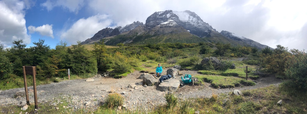
Now to the year 2020: Our trip began in Punta Arenas, where we arrived by plane and hopped a bus to take us a little further north to Puerto Natales, Chile, the gateway to Torres del Paine National Park. We jumped right into it. No time on these “short” trips to get over jet-lag. In Nepal, we had 6 days on the ground before beginning our trek; here, it was exactly 24 hrs after arrival that we threw our packs over our shoulders and hit the trail. The “W” Trek in Torres del Paine is the most popular in Patagonia and we figured we might as well do the best. I will break it down by days, please use the map below to follow along, it will help.

Day #1:
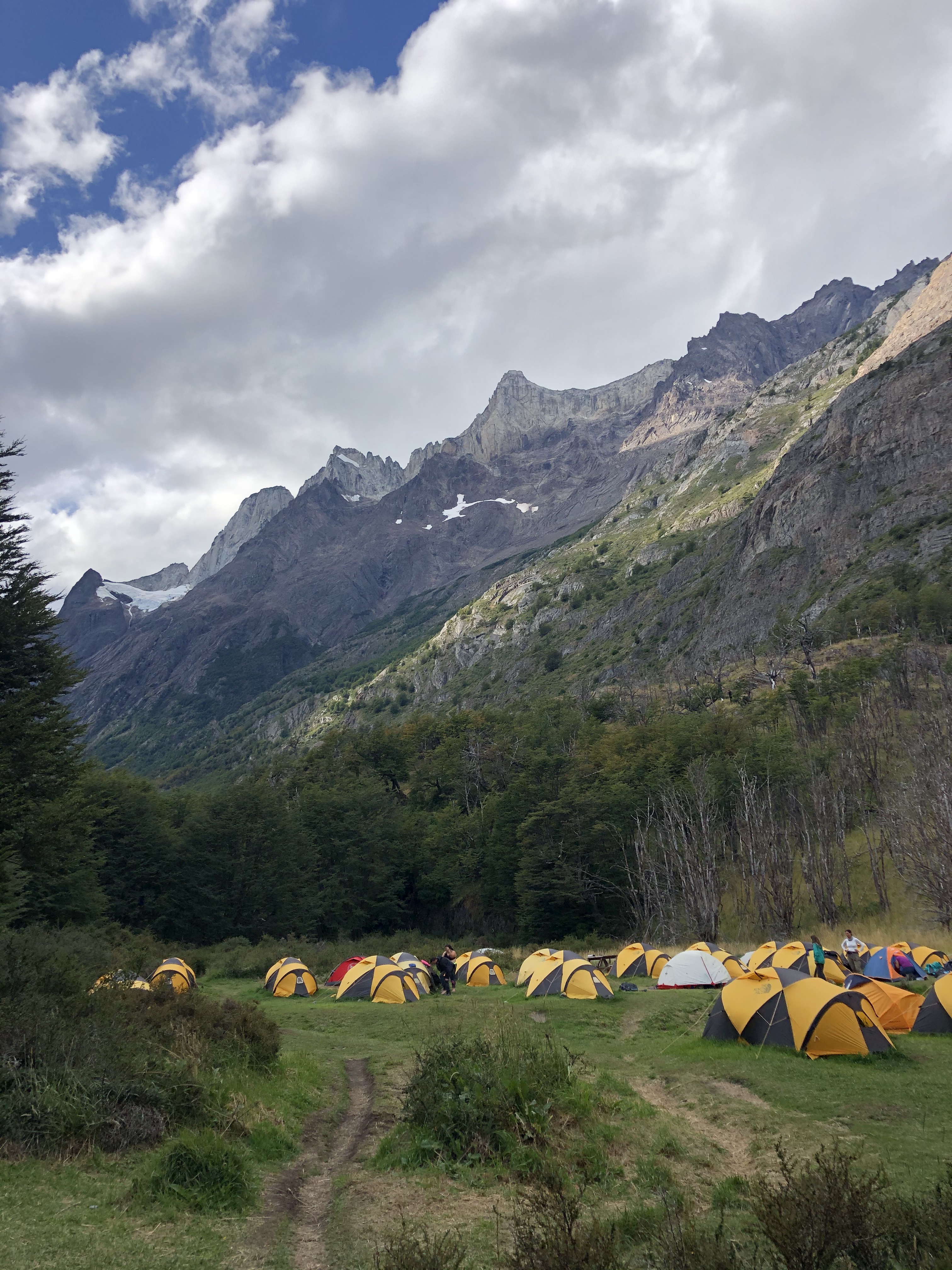
An early morning bus and ferry got us into the park and on the trail at Refugio Paine Grande. The weather was partly cloudy and in the mid-50’s. We had the afternoon to hike the left part of the “W”, up to a ridge along Lago Grey, that gradually descended to Refugio Grey. Most of the Refugios in the park are a combination of lodges with private rooms and bunks that serve expensive meals, and campgrounds with either pre-set tents with pads or pitch-your-own sites. Since the park is very popular, lodgings need to be booked in advance. This trip was a little last minute, so all that was available to us were pre-set tents with pads at all 4 of our stopping points. A little more expensive but honestly a relief to not have to carry our own tent and sleeping pad around the whole trip. We brought sleeping bags and camping pillows from home, along with baggies full of prepared backpacking food, meticulously packed by Julia. After a casual walk out to a Glaciar Grey viewpoint, back in the shared kitchen we ate noodles mixed with StarKist packs of Salmon cooked on a propane stove we had rented for the trek.
(Hike time = 4.5 hrs, Distance = 13 kms)


Day #2:
We got to sleep in a little bit, taking advantage of the favorable sunrise (7:15AM) and sunset (8:30PM), giving us plenty of light to get where we needed to go. Oatmeal with dried fruit was consumed for breakfast. We covered a lot of distance this day. The morning was spent hiking back down to Paine Grande (where the ferry had dropped us off the previous day), where we snacked on jerky and trail mix for lunch before venturing Northeast into the heart of the park and the middle part of the “W”. The weather was perfect this day, mid-60’s and clear skies. We strolled past lakes while skirting the edge of the mountains, taking our time. With plenty of daylight we were in no rush, and realized we preferred to take frequent breaks and let people pass us. Eventually we had the trail to ourselves and it was very peaceful. The last few kilometers of this long day never seemed to end, but we finally made it to our stop for the 2nd night, Camping Frances. We welcomed the warm shower and ate Pad Thai. The tents at this camp were pitched on wooden platforms, giving the place an Ewok village feel. Through the night, we could hear thundering avalanches in the valley above us. At times, I half-expected to hear the camp host yell for everyone to “RUN!”, but trusted that we were safe.
(Hike time = 8.5 hrs, Distance = 20 kms)


Day #3:
After a quick light breakfast, we stored our large packs and backtracked a bit to tackle the rocky middle part of the “W” (refer to trail map above). Unfortunately, we had our worst weather day to see one of the top sites in the park. It was a constant drizzle with few breaks. The first stop was the lookout for the French Valley. It is an impressive sight, with hanging glaciers and the ever present loud rumble of avalanches that are safely at a distance. We turned our heads quickly to spot them but only occasionally saw the accompanying cascading snow. The hike continues up the valley, and after a very steep ascent, finishes at Mirador Britanico. We lucked out and caught an hour long window of dry weather. The view was pretty spectacular from up there, surrounded by rugged peaks and glaciers. We had to fight a little bit for photo position on the boulders but I remember at this point feeling like the trek had already exceeded expectations.
The way back down the valley was slow going as it was wet and the rocks were slippery. We made it back to Camping Frances by mid-afternoon, picked up our large packs, and moved further East. This part was a fairly steep descent, taking us down to the edge of Lago Nordenskjöld, where we briefly walked along the rocky shoreline. Our stop for the 3rd night was at Los Cuernos Refugio & Camping. Set up from the lake a little bit, with mountains right behind you and a waterfall/river to the side, it was the most scenic of all the campgrounds we visited. We ate buffalo chicken and noodles in a crowded communal kitchen.
Quick side note, if you are hiking the opposite direction, you can save yourself some money and pickup a propane container from Los Cuernos. They get left behind by people like us who can’t use them at Chileno and thus no longer need them. There were about 15 on the free shelf when we left.
(Hike time = 10 hrs, Distance = 16.6 kms)


Day #4:
This was a fairly short moving day, so we took our time and ate our granola and dried fruit breakfast. We also pre-cooked our dinner for the night as we learned that we would not be able to use our propane stove at the next campground. We didn’t depart the camp until around 9:30am, sticking to our mantra of not being in a rush and trying to stay behind the pack. This was our quietest day on the trail, we traversed the mountainside and gradually climbed our way up, over Windy Pass and into Valle Ascencio. We were putting ourselves into position to see the main attraction, 3 immense rock towers known as Torres del Paine (you have probably seen a picture of them, if not, you will in the next section). Soon we were at our final campground, Refugio Chileno. From the lodge you could catch a glimpse of the towers in the distance and it was tempting to just run up there and take a look. We opted for relaxing in the tent and an early bedtime.
(Hike time = 6 hrs, Distance = 12 kms)


Day #5:
This was it, the pinnacle of our 5 day trek. It can be risky saving the best for last, there is a chance the conditions let you down and that could spoil the whole trip. The climax of this journey is waking up before 4am so that you can be on the trail by 4:30. We stored our bags in the lodge and broke out our flashlights. Julia had a nice headlamp, and I looked a little silly holding my iPhone (my headlamp broke). We haven’t done much hiking in the dark. It can be a little unnerving, but seeing and hearing other groups in the distance helps. The trail started along the river, slowly heading up the Valle Ascencio, before veering left to hike basically straight up the side of the mountain. This is the toughest stretch of the “W” Trek. Very steep, the ground is loose and rocky, we were exhausted, the only things getting us up that trail were the slow emergence of sunlight and the desire to get to the top before sunrise.
We made it with plenty of time to find a rock to perch on. The towers rose just across a glacial tarn (mountain lake) from us, gradually coming more into focus. The moment we all woke up early for was the first beams of light that perfectly illuminated the towers. The color soon turned orange-ish, and with some light fog hovering around, a rainbow appeared on the rock face. There were gasps and giddy laughter from the onlookers. People were losing their minds. We quickly snapped photos and took it all in. The moment soon passed, as the light source was blocked by clouds, and we felt satisfied with the climax of our trek. With a bus to catch, we descended at a slightly faster pace than normal. After a brief stop to collect our large packs from the lodge at Chileno and a quick snack, we began our last leg of hiking.


This part would typically be pretty boring and seem to drag on as we dreamed of large meals and soft beds, but we had some entertainment. This was the busiest section of the park, and that is due to the massive number of day-hikers who come on tour groups, wanting to get that Instagram picture with the Towers in the background. It is a difficult 19km roundtrip, 900 meters of elevation gain hike from the parking lot that most people we saw had no business attempting. They were out of shape, wore jeans, and made terrible footwear choices. We estimated that half wouldn’t make it to the top. Not that we thought they would die, we just figured they would get to the Chileno lodge, give up, and order a beer. Watching the guides trying to corral and spur them up that mountain was an enjoyable sight.
We made it down in time to catch our transportation back to Puerto Natales and counted our blisters. Finishing something like that is always fun and rewarding.
(Hike time = 7.65 hrs, Distance = 11.3 kms)

Some final thoughts on the “W” Trek; The landscape is amazing and unlike anything we have seen. The infrastructure is great, giving you a few different routing options. I think the West to East route we took is the way to go, leaving the Torres for the end is a nice way to finish. If you want to tackle more, you can extend the trek, making it the “O” or the “Q” by completing a loop around the park.
Lodging is a little expensive, but each site had warm showers and clean facilities. Booking well in advance and bringing your own camping gear can save you a lot. If you have the money, I wouldn’t judge you for staying in rooms and eating in the restaurants. Here is a breakdown of our trekking statistics.
“W” Trek Numbers
Number of days hiking = 5
Distance hiked = 45.2 miles
… miles hiked per day = 9.04
… time spent hiking per day = 7.33 hrs
—–
Total spent on food (majority pre-trip) = $81.30
… cost of food per day = $16.26
Total spent on Lodgings (tents w/sleeping pads) = $328
… cost of lodgings per night = $82
Total spent on transportation to/from Puerto Natales and the park = $100.82
… cost of ferry to Paine Grande (2 people) = $56.63
Park entrance fee (2 people) = $85.88
Equipment rental (camp stove + propane) = $15.46
————————————————————————-
Total Cost of the “W” Trek = $611.46
That wraps up the first 6 days of our trip. We were not quite done with Patagonia yet, so the next post will have even more pictures of glaciers and mountains, including a report on possibly the best day hike I have ever done.
